
EOMAP launches free, daily monitoring program for harmful algae blooms
Broomfield, Colorado
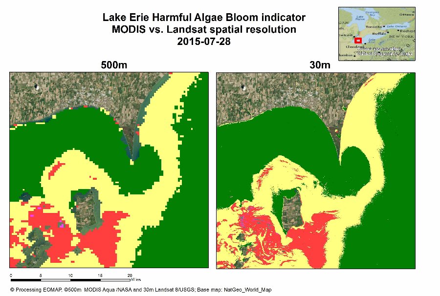
Harmful algae blooms threaten drinking water, aquaculture industries and the public welfare. A significant bloom was recently forecasted for Lake Erie: NOAA predicts that this year’s blooms will be “among the most severe in recent years” and will peak in September.
The bloom is now tracked daily on the free algae bloom monitoring program developed by EOMAP for the Great Lakes region. The solution provides an easy online access through EOMAP’s eoApp®-US. EOMAP also tracks the vast number of smaller lakes and coastal waters globally using its multi-satellite monitoring system and displays this data on the eoApp® web application.
Aside from single, daily products, EOMAP’s eoApp®-US also provides spatially and temporally aggregated data: daily means (D’mean) and moving, weekly means (M’mean).
The eoapp monitoring system allows for tracking blue algae blooms and relevant water quality parameters such as chlorophyll and turbidity. Various US and European satellite sensors are imbedded into this first globally harmonized monitoring system, supporting daily monitoring at continental scales, historical reviews up to 30 years back in time and highest spatial resolutions for ponds, small lakes and rivers.
Matt Bergin, Vice President of business Development at EOMAP states that “EOMAP supports European and US research initiatives to understand and forecast harmful algae blooms. The heavy bloom in 2013 was already well detected and is accessible through eoApp-US. The algorithm developed by EOMAP detects blue algae containing phycocyanin pigments. It is imbedded into the proprietary, state-of-the-art satellite data processors of EOMAP, which already are installed in several satellite receiving and archiving centers to support the most cost efficient and fast production.”
References
- eoApp®-US
- EOMAP Water Quality Information Booklet
- For more information please contact Matthew Bergin or use our contact form.

Latest EOMAP News

Reuters bases Mekong article on EOMAP data
The Development of EOMAP’s Water Quality Platform

UNESCO Water Quality Portal launched

Launching the world’s first comprehensive global water quality atlas with UNESCO

Oman Oil Spill: SDB Mapping of Critical Shallow Waters for Safe Salvage

eoapp DIVE unterstützt die Tauchplanung
Related Posts
09 / 2026
The Development of EOMAP’s Water Quality Platform
09 / 2026
UNESCO Water Quality Portal launched

08 / 2026
Launching the world’s first comprehensive global water quality atlas with UNESCO

08 / 2026
eoapp DIVE unterstützt die Tauchplanung
06 / 2026
Dredge plume monitoring using satellite-based turbidity mapping
04 / 2026
Advocating for Healthy Mountain Ecosystems

04 / 2026
Environmental monitoring for sporting events

04 / 2026
20 Years EOMAP: Advancing Earth Observation

03 / 2026
New BD & Sales Manager for the Americas
03 / 2026

