Effective Surveying Tool For The Shallow Water Zone
Bathymetric data in the shallow water zone is of increasing importance to support various applications such as safety of navigation, reconnaissance surveys, coastal zone management or hydrodynamic modelling.
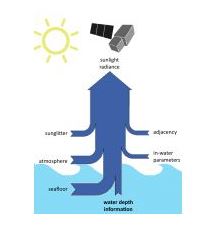
A gap was identified between data demand, costs and the ability to map with ship and airborne sensors. This has led to the rise of a new tool to map shallow-water bathymetry using multispectral satellite image data, widely known as Satellite Derived Bathymetry (SDB).
Strictly speaking the methods to derive information on seafloor topography using reflected sunlight date back to the 1970’s but it has required iterative improvements of algorithms, computational power, satellite sensors and processing workflows in order to provide the current state of the art.
Today, a range of different methods exist under the umbrella of the SDB term. However, as with traditional survey methods it is imperative to understand the advantages, disadvantages and overall feasibility in order to evaluate the suitability and fit-for-purpose of a given SDB application.
Bathymetric Data Production
Historically, empirical methods were used, which require known depth information over the study area. By comparing these known depths with the satellite signal, a statistical relationship can be derived that adequately describes depth as a function of the signal. Aside from requiring known depth data, these methods will only work for a given satellite image.
A subsequent satellite scene, even of the same location, may contain different atmospheric and in-water parameters, and thus the statistical relationship needs to be re-calculated. Another aspect of these methods is that the statistical relationship is only valid for one water type and one seafloor type. Therefore, when an area contains different types such as coral, sediment, algae and rubble, the statistical relationship needs to be calculated for each of these substrate types.
To read the full article on SDB methods, data integration and three use cases, please go to https://www.gim-international.com/content/article/the-increasing-importance-of-satellite-derived-bathymetry.[:]

Latest EOMAP News

Reuters bases Mekong article on EOMAP data

Cyanobacteria on the rise – algal blooms in bathing waters

SDB Update #7 – Topobathy of the Red Sea

SDB Update #6 – Satellite-based Topobathy Models

SDB Update #5 – Storymap on Satellite-Derived Bathymetry

SDB Update #4 – Northern Canada’s shallow waters mapped in 100 m
Related Posts

08 / 2025
SDB Update #7 – Topobathy of the Red Sea

07 / 2025
SDB Update #6 – Satellite-based Topobathy Models

07 / 2025
SDB Update #5 – Storymap on Satellite-Derived Bathymetry

06 / 2025
SDB Update #4 – Northern Canada’s shallow waters mapped in 100 m

06 / 2025
SDB Update #3 – The Maldives’ shallow waters mapped in 100 m

05 / 2025
SDB update #2 – The Bahamas mapped in 10 m

05 / 2025
Planet contract: Supporting Germany’s water monitoring

05 / 2025
SDB update #1 on Australia: All shallow waters mapped

03 / 2025
German Innovation Prize 2025 – EOMAP listed among top 3

03 / 2025
