An effective surveying tool for shallow-water bathymetry mapping
Satellite-derived bathymetry – SDB | Remote sensing | Earth observation | Mapping depth
It is based on the concept of using the reflectance intensity of different wavelengths (colours) of the sunlight which is recorded by the satellitesensor. This information in combination with relevant databases and physical modelsdetermines the shallow water depth down to the light penetration depth. In the lastdecade, there has been an increasing interest of SDB methods and derived data. Various exercises have been done by academia and industry to validate and evaluate SDB data sets (REF). This awareness is based on two major developments: the recent availability of very high resolution satellite data mapping the seafloor in sufficient detail and the design of robust and standardised algorithms and workflows.
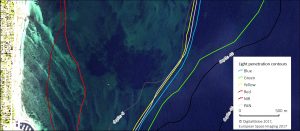
Fig. 1: Maximum light pen-etration depth of sunlight highlighted for the Baltic Sea (Denmark) using very high-resolution WorldView-2 satellite image data. The colours represent the different wave-lengths of the sensor (colours) which are overlaid by 5 m and 10 m depth contours of the nautical chart. With increasing depth seafloor reflectance is dominated by shorter wavelengths. In organic rich waters such as the Baltic Sea the green wavelength(s) penetrate deepest.
Satellite data sources: Whole earth imagery and its archives

Latest EOMAP News

Reuters bases Mekong article on EOMAP data

Cyanobacteria on the rise – algal blooms in bathing waters

SDB Update #7 – Topobathy of the Red Sea

SDB Update #6 – Satellite-based Topobathy Models

SDB Update #5 – Storymap on Satellite-Derived Bathymetry

SDB Update #4 – Northern Canada’s shallow waters mapped in 100 m
Related Posts

08 / 2025
SDB Update #7 – Topobathy of the Red Sea

07 / 2025
SDB Update #6 – Satellite-based Topobathy Models

07 / 2025
SDB Update #5 – Storymap on Satellite-Derived Bathymetry

06 / 2025
SDB Update #4 – Northern Canada’s shallow waters mapped in 100 m

06 / 2025
SDB Update #3 – The Maldives’ shallow waters mapped in 100 m

05 / 2025
SDB update #2 – The Bahamas mapped in 10 m

05 / 2025
Planet contract: Supporting Germany’s water monitoring

05 / 2025
SDB update #1 on Australia: All shallow waters mapped

03 / 2025
German Innovation Prize 2025 – EOMAP listed among top 3

03 / 2025
