Shallow waters represent the most crucial aquatic zones on Earth. They are particularly difficult to survey. Therefore, The Nippon Foundation-GEBCO Seabed 2030 Project has reached a cooperation agreement with EOMAP. The German company is a global expert on shallow water bathymetry from satellite data. It will contribute to the common target: a freely available Ocean Map.
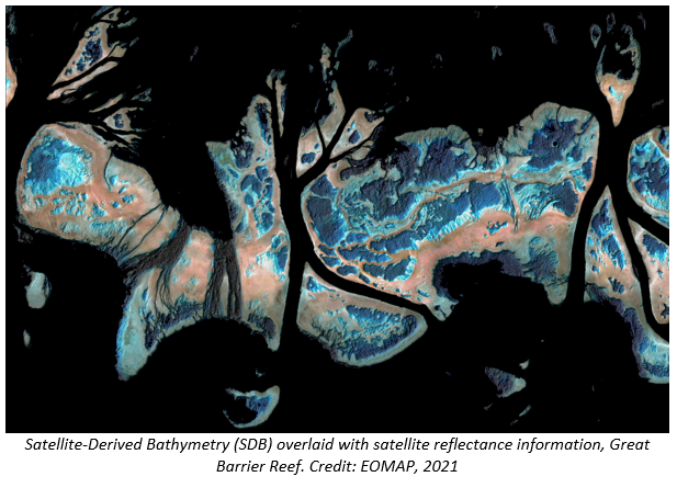
The image shows Satellite-derived Bathymetry data of the Great Barrier Reef (AUS). They can provide a better understanding of aquatic zones and thus help protecting our oceans.
“Mapping the coastal zones of our oceans can be very complex. So we’re delighted to welcome the expertise and support of EOMAP,” commented Jamie McMichael-Phillips, Project Director of Seabed 2030.
“Despite the ocean covering over 70% of the Earth’s surface, around 20% of it has been mapped to date. We have joined the ambitious Seabed 2030 project to contribute with bathymetric data. These are hard or impossible to access otherwise. Our contribution will be – in cooperation with our clients and stakeholders – to fill data gaps in coastal shallow waters and to encourage others to join in”, said Dr. Knut Hartmann, COO of EOMAP.
Coastal zones are not only critical for biodiversity, coastal protection, navigation and other aspects, they are also subject to constant change. Nevertheless, many are not sufficiently understood. By satellite data and smart analytics, we can map and monitor these shallow waters in space, in time and on various scales. EOMAP’s mission is to apply and refine these methods and thus support sustainable management practices.
For more detailed information on cooperation project, please visit seabed2030.org
Find the detailed press release on the new cooperation here.
For further details, images or interview partners, please contact Andrea Schmölzer: schmoelzer@eomap.com
![]()

Latest EOMAP News

Reuters bases Mekong article on EOMAP data

WATCOR‑X Bathymetry Software for Navies and Hydrographic Offices

Quick Facts: Ancient Lakes

Space-based Intelligence for Clean Energy
Bathymetry in the Gulf of Mexico

Pro-active hydropower management in winter
Related Posts

02 / 2026
WATCOR‑X Bathymetry Software for Navies and Hydrographic Offices

01 / 2026
Bathymetry in the Gulf of Mexico

12 / 2025
A short recap of 2025

11 / 2025
Projektstart SEAGUARD

10 / 2025
SDB Update #9 – Validation and Accuracy

10 / 2025
SDB Update #8 – Multisource Bathymetry

08 / 2025
SDB Update #7 – Topobathy of the Red Sea

07 / 2025
SDB Update #6 – Satellite-based Topobathy Models

07 / 2025
SDB Update #5 – Storymap on Satellite-Derived Bathymetry

06 / 2025
