EOMAP and MarineFIND pool their expertise to produce easy access marine data
Seefeld/Germany
Working together, EOMAP GmbH & Co KG and MarineFIND, the specialist marine data and service division of FIND Maps, have formed a partnership to offer easy access to coastal high resolution and global bathymetry.
Collecting nearshore zone bathymetry data has, until recently, been an expensive undertaking. However, advances in the processing of satellite imagery means that low-cost, accurate, high resolution bathymetry to a depth of 20m is now available. The EOMAP/MarineFIND partnership has developed a new method for easily distributing this data for preprocessed areas and allows the production of cost-effective custom datasets.
Dr Thomas Heege, CEO of EOMAP, said: “We’ve worked with MarineFIND on several recent projects and the partnership has delivered excellent results for our clients. Building on the work we’ve already done together, we can now deliver bathymetric and other marine data to many more clients worldwide.”
Jon Coleman, Marine Business Manager of MarineFIND, said: “MarineFIND.co.uk is already one of the industry’s leading GIS portals for marine data. Our expert developers have improved delivery mechanisms allowing us to serve cost-effective high quality marine GIS data directly to client desktops via WMS technology.”
Nigel West, of ABPmer, said: “We’re very happy with the satellite derived bathymetry from EOMAP/MarineFIND. It has proved invaluable for the characterisation of shallow coastal areas in the Red Sea and Mediterranean Sea. In our areas of interest, satellite imagery showed shallow bathymetric features that were either inaccessible to survey vessels or beyond the remit of the original surveys. The data we received from MarineFIND showed good validation with our echo-sounder collected data.”
EOMAP is the leading and largest commercial supplier of satellite-derived high resolution bathymetry and near-real-time water information products. Clients profit from rapid turnaround times on all scales through EOMAP partner network with DigitalGlobe and global space agencies.
EOMAP holds a unique shallow water bathymetry database that is now available through MarineFIND
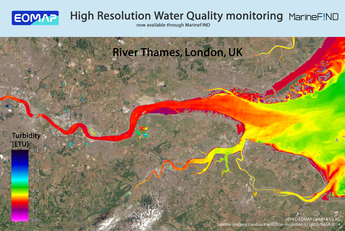
Since 2006, EOMAP has provided marine services to clients in the O&G, coastal engineering and environmental sectors. Applications of their large scale techniques include mapping benthic habitats and bathymetry for the Environmental Agency of Abu Dhabi and mapping the whole of the Great Barrier Reef. Recently, EOMAP launched a WaterQuality App to provide easy access to data for Australia (http://eoapp-au.eomap.com/). The aim of their latest partnership with MarineFIND is to extend the provision of easy access to usable, complex data.
Dr Thomas Heege, CEO of EOMAP, said: “MarineFIND is a unique portal for marine data and we’re happy that it now offers our competitively priced Satellite Derived Service.”