Press release
Mercator Ocean International contracts EOMAP to provide global shallow water bathymetry for the Copernicus Marine Service.
Deltares and GGS Geo Consultancy team up with EOMAP to foster European oceanographic excellence. The three specialists in aquatic environments will provide bathymetry from satellite data for shallow waters worldwide.
 Seefeld, Toulouse – November 2023 – Coastal zones, at the interface of land and ocean, are of tremendous social, economic, and ecological value: About 40% of the world population is currently living within 100 km of the coast, with three quarters of all large cities being situated along coastlines. Coasts are also home to biodiverse habitats storing much more carbon than forests per equivalent area. Their high importance stands in contrast to the lack of knowledge and existing monitoring routines on a global scale.
Together with its partners Deltares and GGS Geo Consultancy (GGSgc), team lead EOMAP will now provide global coastal bathymetric data to fill this knowledge gap. Bathymetry, the underwater topography, is a key environmental parameter for a wide range of coastal applications, such as modelling and hazard assessment, seafloor classification, and quantifying habitat loss or carbon storage capacity.

Angélique Melet – oceanographer at MOi
The Copernicus Marine implemented by Mercator Ocean International (MOi) prioritizes the development of a coastal extension to the service. The satellite-derived bathymetry products to be developed for the Copernicus Marine Service starting with this contract will complement activities of EMODnet bathymetry. This is in line with the high-level agreement between the EU DG DEFIS and DG MARE for the coordination of activities between Copernicus Marine and EMODnet. “For knowledge-based decision-making on coastal issues, reliable open data that describe, monitor and forecast the environment is key. Nearshore bathymetry datasets as delivered by this project strengthen the Copernicus Marine Service portfolio, as it will now provide better monitoring of coastal zones, maximizing the use of Copernicus Sentinel missions; this is one of the top priorities for the Copernicus Marine Evolution.” says Angélique Melet, an oceanographer at MOi.

Mona Reithmeier – project manager at EOMAP
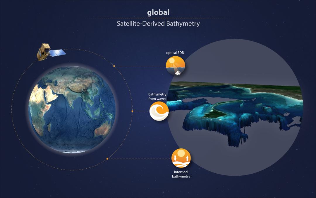
EOMAP as project lead will capitalise on its 20 years’ expertise in satellite-derived bathymetry (SDB): “The project will combine multiple techniques to provide global shallow water bathymetry from satellite data. Our focus will be on optical bathymetry and that derived from wave kinematics”, explains Mona Reithmeier, project manager at EOMAP.

Etiënne Kras – researcher at Deltares
This will be complemented by intertidal bathymetry from the globally recognised Dutch knowledge institute for water and the subsurface, Deltares, and its established modelling know-how: “By integrating our trusted water level modelling with an analysis of the comprehensive Sentinel-2 data archive, we’re pioneering global solutions for quality-assessed intertidal bathymetric data. This approach addresses the ever-growing need for consistent coastal mapping in both data scarce and rich environments, providing crucial information to several applications like morpho-dynamic modelling.” reports Etiënne Kras, an advisor / researcher in Resilient Ports & Coasts at Deltares.
George Spoelstra – Managing Director of GGSgc
In view of the global scale of the project, George Spoelstra, the managing director of GGSgc, will add his international experience as an expert in marine cartography and bathymetry: “Working on a global dataset comes with several challenges: It not only requires scaling-up of data processing routines, but also merging different datasets, quality and coordinate systems. Luckily, we can build on our experience from the European EMODnet Bathymetry project which – in return – will benefit from the project results.”
The strong need for global ocean mapping is also addressed by The Nippon Foundation-GEBCO Seabed 2030 Project. Therefore, Jamie McMichael-Phillips, the director of Seabed 2030, states: “We strongly support the objectives of the project which is in line with the Seabed-2030 mission to deliver a complete map of the seabed.”
Apart from global bathymetry data, the MOi contract touches another challenging aspect: Due to sediment movement, erosion, or sand deposition, shorelines and underwater topography are changing constantly. This is why the team will also test satellite-based monitoring of morpho dynamics in various coastal zones across the globe, preparing a roadmap for global monitoring routines.
Please find a Download-Link of text and free imagery below.
About Mercator Ocean International (MOi)
Mercator Ocean International (MOi) is a non-profit organisation, in the process of transforming into an intergovernmental organisation since the ‘Brest Declaration’ at the One Ocean Summit 2022. MOi provides ocean science-based services focused on the conservation and the sustainable use of the ocean and marine resources. In 2014, MOi was entrusted by the European Commission to implement the European ocean-monitoring service, the Copernicus Marine Service, as part of the Earth observation component of the European Union’s Space programme, Copernicus. This service is free, open to all and operates a web portal with nearly 600 000 visitors in 2023 and some 65 000 registered users.
About EOMAP
EOMAP, established in 2006, is an earth observation and software solution company. With its headquarters in Munich and global affiliations, EOMAP provides data, software, and intelligence ‘powered by space’ to industry, governments, and academia. EOMAP has received various awards for technological excellence and keeps partnering in European innovation projects. The team’s overarching goal remains to support the sustainable management of the world’s key resource: water.
Media Service
- Infographic of global Satellite-Derived bathymetry – explaining the 3 components: optical SDB, bathymetry from waves and intertidal SDB
In case of further questions, please reach out to shallowwater@eomap.de
Find more news at the EOMAP Press Room.
About Deltares
Deltares is an independent (not-for-profit), world-leading, and mission-driven Dutch knowledge institute for water and the subsurface. Deltares works throughout the world, and is guided by the major societal issues, for which Deltares’ knowledge is indispensable. This is what drives Deltares highly qualified 800 colleagues, a team composed by over forty different nationalities. With over 100 years of experience, Deltares develops in-depth knowledge through applied research that is essential and beneficial for decision-making.
About GGS Geo Consultancy BV (GGSgc)
GGSgc is a specialized technical consultancy firm based in the Netherlands and active in the (hydrographic/oceanographic) Geo-ICT industry. GGSgc specialises in cloud-based software development, data processing, project management, interim management and training. GGSgc builds on years of experience in the hydrographic/oceanographic and cartographic business both for government and industry. Finding solutions instead of chasing rainbows is what drives the company. Over the years, GGSgc has been particularly active in OGC compliant viewing and download services for the European EMODnet project.
Latest EOMAP News

Reuters bases Mekong article on EOMAP data

UKHO’s highest-ranked Satellite-Derived Bathymetry provider in 2015

Mapping the ‘unmappable’ Great Barrier Reef

Dredge plume monitoring using satellite-based turbidity mapping

Pioneering seagrass mapping at the Italian coastline in 2006

Mapping Ningaloo Reef 2009: A Breakthrough in Hyperspectral Marine Habitat Analysis
Related Posts

07 / 2026
UKHO’s highest-ranked Satellite-Derived Bathymetry provider in 2015

06 / 2026
Mapping the ‘unmappable’ Great Barrier Reef

05 / 2026
Pioneering seagrass mapping at the Italian coastline in 2006

04 / 2026
Mapping Ningaloo Reef 2009: A Breakthrough in Hyperspectral Marine Habitat Analysis

04 / 2026
Environmental monitoring for sporting events

04 / 2026
20 Years EOMAP: Advancing Earth Observation

03 / 2026
New BD & Sales Manager for the Americas

02 / 2026
WATCOR‑X Bathymetry Software for Navies and Hydrographic Offices

01 / 2026
Bathymetry in the Gulf of Mexico

01 / 2026
