Press release
Surveying Shallow Water – easy and online –
EOMAP launches SDB-Online, the new WebApp for Satellite-Derived Bathymetry
(Seefeld, Germany – June 2022)
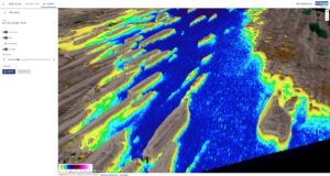
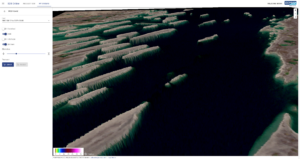
SDB-Online is the new cloud-based WebApp to create high-resolution bathymetric grids for shallow waters. As the first of its kind it builds on EOMAP’s expertise in Satellite-Derived Bathymetry (SDB), a technique to map water depth from space, avoiding time consuming and costly on-site surveys. With SDB-Online, coastal engineers, surveyors, modellers or scientists can create high-resolution bathymetry grids 24/7, from the comfort of their desks.
“EOMAP’s SDB-Online is delivering fast and accurate results without the need of ground control data, processing 10 scenes in less than one hour. The “Combine” option (multi-image processing) is a game changer in challenging locations, especially with frequent cloud cover or heavy vessel traffic”, says Véronique Jégat, Senior Geo-Data Engineer at Fugro.
In addition, bathymetric power users can integrate SDB-Online via API into their own software solutions, like QPS does: “During our prototyping, I was impressed how quickly things came together for the two development teams. Particularly elegant was how EOMAP combined multiple images of the same area to give the best possible depth estimate. The workflow is already very smooth, and now we‘re keen to work with early adopters to advance these tools“, reports Jonathan Beaudoin, Managing Director, QPS B.V.
Underwater topography – bathymetry – is crucial for many different coastal stakeholders: On the basis of bathymetric data, coastal engineers calculate and plan their projects, surveyors decide where to set up on-site campaigns, modellers analyse and predict coastal dynamics, while scientists study seabed morphology and benthos. So far, they often had to either perform work and cost intensive on-site surveys or to rely on insufficient data from other sources. SDB-Online helps: It enables the above users to access high resolution bathymetric grids of shallow waters without on-site surveys – rapidly and easily.
“Experts managing or studying coastal shallow waters will experience an incredible time and information gain: Within minutes they can trigger automated processing routines and receive high-res bathymetry data for their projects“, says Mona Reithmeier, SDB-Online manager and SDB expert at EOMAP.

Mona Reithmeier – Product Lead SDB-Online
For more than two decades, EOMAP has been pioneering in Satellite-Derived Bathymetry (SDB). This technology allows to calculate water depth data by inverting sunlight’s way through atmosphere and water, harnessing multispectral satellite imagery. On SDB-Online, this complex process is now running automatically – basically in four steps: Once the user has accessed SDB-Online via her or his browser, she/he defines an area of interest anywhere on Earth using the map. A – manual or AI trained – image selection process starts and is linked to satellite data archives of the European Space Agency (ESA). Following that, the physics based SDB analysis creates the gridded bathymetry surface that align with ISO and OGC standards. As an option, QAQC processes by EOMAP’s data analysts or seafloor classification can be added.
Satellite-Derived Bathymetry is EOMAP’s key expertise. In 2015 and 2022, EOMAP was selected top-ranked SDB provider by the UK Hydrographic Office. Moreover, EOMAP’s bathymetric data are featured in nautical charts and the European harmonized bathymetry grid EMODnet Bathymetry. Coastal planners and engineers, surveyors and hydrographers all over the world value EOMAP’s SDB expertise and data.
SDB-Online has been developed with co-funding by EU Horizon 2020 innovation program.
Link: sdb-online.eoapp.de
Contact: sdb-online@eomap.com
Notes to the Editor:
About EOMAP
The international team of water enthusiasts turns satellite data into value for coastal and inland water stakeholders. By data products and software services EOMAP wishes to advocate a more effective and sustainable management of coastal and inland waters.
Clients around the world value the team’s deep understanding of aquatic environments. They enjoy the panoptic view they gain on the water bodies of their interest and a growing number of software tools for easy access to satellite data. The German tech company was founded in 2006, has its headquarters near Munich and maintains offices in Australia, USA, Indonesia and in the United Arab Emirates.
eomap.com
Satellite-Derived Bathymetry (SDB)
SDB is a rising technique using satellite data records and analytical methods for producing “digital twins” of shallow waters. EOMAP’s SDB concept is to quantify water depth by inverting the radiative transfer model. This model describes the modulation of sunlight as it passes through the atmosphere, water surface, water column and is reflected back to the satellite sensor from the seafloor. In short, water depth is derived from light energy in different wavelengths which are recorded by satellites. Compared with ship and airborne survey methods, SDB allows mapping extensive aquatic zones remotely and within a fraction of time. SDB data by EOMAP have been integrated into various nautical charts, are part of the European harmonized bathymetric grid, serve the management of the Great Barrier Reef and many other coastal stakeholders. Advances in accuracy and awareness of this effective surveying method keep driving the demand.
For more information, please contact:
EOMAP Media Relations: schmoelzer@eomap.com – phone: +49 (0) 8152 9986 110

Latest EOMAP News

Reuters bases Mekong article on EOMAP data

UKHO’s highest-ranked Satellite-Derived Bathymetry provider in 2015

Mapping the ‘unmappable’ Great Barrier Reef

Dredge plume monitoring using satellite-based turbidity mapping

Pioneering seagrass mapping at the Italian coastline in 2006

Mapping Ningaloo Reef 2009: A Breakthrough in Hyperspectral Marine Habitat Analysis
Related Posts

07 / 2026
UKHO’s highest-ranked Satellite-Derived Bathymetry provider in 2015

06 / 2026
Mapping the ‘unmappable’ Great Barrier Reef

04 / 2026
Mapping Ningaloo Reef 2009: A Breakthrough in Hyperspectral Marine Habitat Analysis

04 / 2026
Advocating for Healthy Mountain Ecosystems

04 / 2026
20 Years EOMAP: Advancing Earth Observation

03 / 2026
New BD & Sales Manager for the Americas

02 / 2026
WATCOR‑X Bathymetry Software for Navies and Hydrographic Offices

01 / 2026
Bathymetry in the Gulf of Mexico

01 / 2026
Pro-active hydropower management in winter

12 / 2025
