EOMAP awarded new survey contract by UKHO
The UK Hydrographic Office (UKHO) have signed a new three-to-five-year framework contract for Satellite-Derived Bathymetry (SDB) with EOMAP. In the course of a competitive tender the German based experts for Earth Observation have – again– been ranked first-choice provider of SDB. The first batch covers 9,000 sqkm shallow waters of Belize.
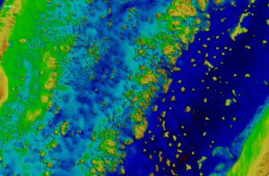
Very high-res. SDB record by EOMAP, Lighthouse Reef, Belize – first engagement for UKHO 2022 – © MAXAR
Seefeld, Germany – February 2022
Starting 2022, EOMAP will deliver high-resolution shallow water grids from SDB technology to UKHO, with the first survey covering the waters of Belize. This survey will be the first complete survey of some of these waters, including where uncharted coral pinnacles are currently noted on the chart.
“The UKHO is pleased to be continuing our partnership with EOMAP, leveraging cutting-edge survey technology like SDB to supplement existing hydrographic surveying and related charting products. SDB adds significant value and cost-effectiveness when surveying difficult-to-access areas of the ocean, while minimising the impact on the marine environment“, says Ian Davies, International Hydrographic Portfolio Manager, UKHO.
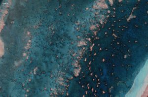
Satellite reflectance product, corrected for effects of atmosphere and water surface, hillshaded with EOMAP’s very high resolution SDB record, Lighthouse Reef, Belize – © MAXAR
“It’s a pleasure to complement UKHO’s survey capabilities. We are already working on the first engagement: Mapping Belizean waters covering an area of 9,000 square kilometres”, explains Knut Hartmann, COO of EOMAP. “For us, this contract is a proof of trust in the quality of our satellite analytics. Moreover, it shows that our SDB technology is a must-have in the toolbox of modern hydrographers and surveyors, when it comes to mapping shallow waters.”
In 2015, EOMAP was selected as the first-choice provider by UKHO for the first time. Within this framework contract, their satellite analytics had been included in the ADMIRALTY Navigational Chart 2066 of Southern Antigua, Caribbean. In addition to surveyors and hydrographers, coastal zone managers, planners and engineers all over the world value these shallow water grids for their work.
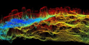
3D visual of high-res SDB point cloud by EOMAP, Lighthouse Reef, Belize
Notes to the Editor:
Satellite-Derived Bathymetry (SDB)
SDB is a rising technique using satellite data records and analytical methods for producing “digital twins” of shallow waters. EOMAP’s SDB concept is to quantify water depth by inverting the radiative transfer model. This model describes the modulation of sunlight as it passes through the atmosphere, water surface, water column and is reflected back to the satellite sensor from the seafloor. In short, water depth is derived from light energy in different wavelengths which are recorded by satellites. Compared with ship and airborne survey methods, SDB allows mapping extensive aquatic zones remotely and within a fraction of time. SDB data by EOMAP have been integrated into various nautical charts, are part of the European harmonized bathymetric grid, serve the management of the Great Barrier Reef and many other coastal stakeholders. Advances in accuracy and awareness of this effective surveying method keep driving the demand.
About the UK Hydrographic Office (UKHO)
The UK Hydrographic Office is a leading centre for hydrography, providing marine geospatial data to inform maritime decisions. They work with a wide range of data suppliers and partners to support maritime navigation, safety, security and marine development around the UK and worldwide.
The UKHO make location-based information available through ADMIRALTY Maritime Data Solutions, their world-leading range of charts, publications and custom data sets. They source, process and provide access to location-based information, ranging from seabed to surface. This enables partner organisations to make critical maritime decisions – informing the sustainable use and management of the marine environment and supporting the development of the blue economy.
gov.uk/ukho
About EOMAP
EOMAP provides high quality satellite-derived data products and software services for a panoptic view on coastal and inland waters. Via a better understanding of this crucial environment, the international team wishes to contribute to a sustainable management. Founded in 2006, EOMAP has its headquarters near Munich, Germany and maintains offices in Australia, USA, Indonesia and in the United Arab Emirates.
eomap.com
For visuals in high-resolution, interview partners or more details, please contact Andrea Schmölzer. – Thank you.

Latest EOMAP News

Reuters bases Mekong article on EOMAP data

UKHO’s highest-ranked Satellite-Derived Bathymetry provider in 2015

Mapping the ‘unmappable’ Great Barrier Reef

Dredge plume monitoring using satellite-based turbidity mapping

Pioneering seagrass mapping at the Italian coastline in 2006

Mapping Ningaloo Reef 2009: A Breakthrough in Hyperspectral Marine Habitat Analysis
Related Posts

07 / 2026
UKHO’s highest-ranked Satellite-Derived Bathymetry provider in 2015

06 / 2026
Mapping the ‘unmappable’ Great Barrier Reef

04 / 2026
Mapping Ningaloo Reef 2009: A Breakthrough in Hyperspectral Marine Habitat Analysis

04 / 2026
20 Years EOMAP: Advancing Earth Observation

03 / 2026
New BD & Sales Manager for the Americas

02 / 2026
WATCOR‑X Bathymetry Software for Navies and Hydrographic Offices

01 / 2026
Bathymetry in the Gulf of Mexico

12 / 2025
A short recap of 2025

10 / 2025
SDB Update #9 – Validation and Accuracy

10 / 2025
