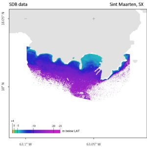
Satellite-Derived Bathymetry chart of Sint Maarten, in the clear water of the Netherland Antilles – c/EOMAP for 4S
The following two figures illustrate the SDB results and the scatterplot of SDB versus traditional bathymetry survey data at the 4S use case in Sint Maarten, Netherland Antilles.
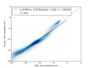
Validation plot of the use case in the Netherland Antilles.
The Sint Maarten use case represented the water conditions with the clearest waters. The extremely high water clarity of these Caribbean waters allowed to apply Satellite-Derived Bathymetry to map the seafloor down to 20 meters depth.