The Mekong River is a vital lifeline for millions of people in half a dozen countries. It provides one of the world’s most productive inland fisheries, and 71% of rural Laotian households rely on subsistence fishing on the Mekong. Over one million Cambodians are almost entirely dependent on Tonle Sap Lake, Southeast-Asia’s largest freshwater lake that connects to the river.
Cambodia, Laos, Thailand and Vietnam have collectively built 40 dams along the river, with an additional 80 planned. China has already built seven dams for hydro-power at the Mekong, which have become one of the country’s largest sources of energy. Downstream countries have long voiced their fears about declining and erratic water levels as well as a decrease in the amount of sediment washed down from the Chinese highlands.
Nutrient-rich sediments are trapped within the reservoirs behind the dams and can therefore no longer reach the delta region, where they are highly important to not only the ecology, but also to the agricultural economy.
Serious ecological problems such as droughts or salinification will have to be faced as a result of reduced river flow from dams and climate change.
It is essential for high-level water-resource-management of governmental bodies to access local, country-wide or global status information and trends of water quality in inland surface waters, but also for many practical and actual water related issues such as sedimentation in dams or cyanobacteria blooms in water reservoirs and bathing lakes. Information on sediments in the water column, algae blooming and eutrophication can support efficient planning on localized comprehensive measurements, environmental impact or directive monitoring.
With mega-dams planned globally, especially in the Amazon and Mekong, assessing the various impacts of dams
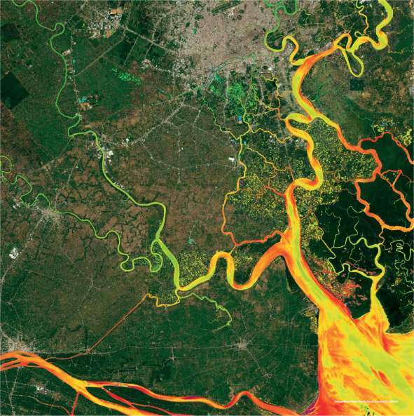
Mekong Delta, Vietnam: Turbidity parameter
such as biodiversity, reduction in a waterway’s nutrient and sediment flow alongside the economic viability is a complex task and efficient planning on localized comprehensive measurements and continuous planning are essential.
A network of commercial and scientific German and Vietnamese partners is ready to provide a powerful information system containing highly relevant hydrology, sociology and EO data to enable efficient decision making and capacity building.
The Catch-Mekong project’s main goal is to integrate EO and in-situ monitoring with water quality models and quality data for the Mekong Delta. This will provide a decision supporting tool to impact to salinification as well as coastal instabilities and specific environmental challenges in the Mekong Delta.
Water resource development projects and water management systems in the Mekong region require consistent dynamic spatial and temporal information for long-term monitoring purposes.
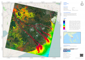
Satellite-derived data will provide key information on river bed detection, water turbidity, sedimentation and other organic components.
EOMAP is responsible for the operational processing of satellite-derived coastal morphological data such as water depth information in turbid waters and is involved in further algorithm development.
For further information, please email us at marketing@eomap.de.
Featured image shows false colour composite of the Mekong Delta at 10 m resolution, derived from all available satellite images from Sentinel-2 collected in 2016-2017.