News

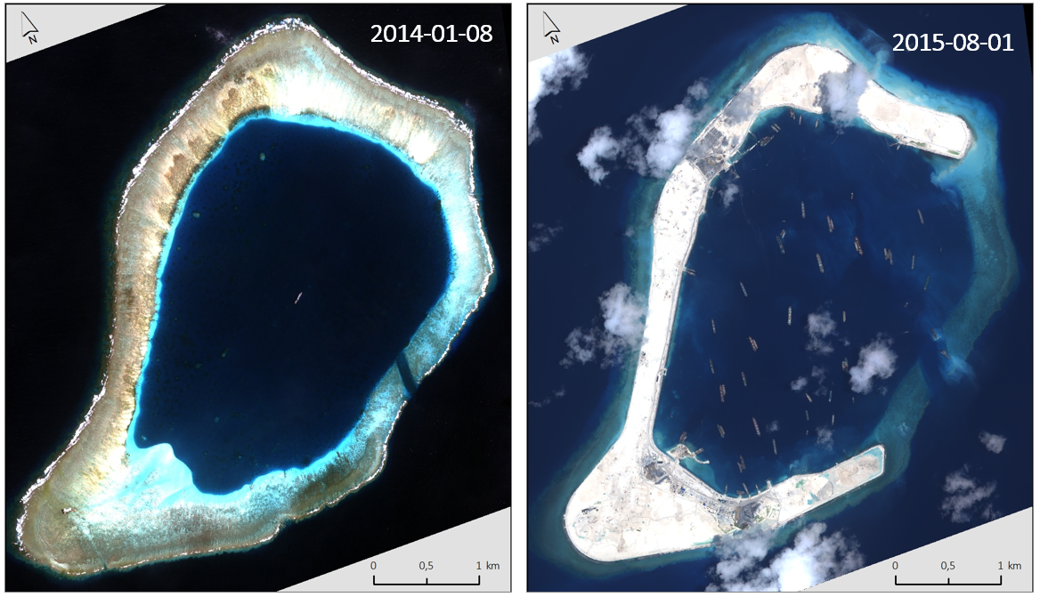
How satellite data support maritime boundary disputes
|, , , ,
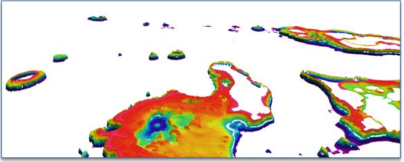
Coastline delineation and coastline dynamics When it comes to maritime boundary disputes between two States the core questions in a case are often about the identification of the coastline used...
continue reading
Optimizing hydrographic survey campaigns with Satellite-Derived Bathymetry
|, , ,
Seefeld, October 2018, EOMAP, together with iXblue, have mapped Satellite-Derived Bathymetry (SDB) for the Tongan archipelago. The project partners were contracted by the Land Information New Zealand (LINZ). The SDB...
continue reading
Satellite-Based Water Quality Monitoring for Hydropower Development in Georgia
|, , ,
Seefeld, October 2018 EOMAP has provided satellite-based water quality monitoring for Georgia's river system to support strategic assessment of the power sector development in this region.  The economic and ecological...
continue reading
Satellite Data Services for the Maritime Industry: Potential Value unlocked
|, , , ,
Hamburg, September 2018 Following the success of last year’s workshop, MarSat, a corporate network of four private companies and a research institute, hosted its second workshop on the potential value...
continue reading
Access Shallow-Water Bathymetry You Need: New EO Store Bathymetry launched
|
The new EO Store Bathymetry expands the comfort zone of coastal engineers and surveyors EOMAP has launched the world’s first commercial online store for global shallow-water bathymetry using satellite data....
continue reading
New Maritime Workshop on Satellite Services
|, , , ,
A new maritime workshop on satellite services is organized again by MarSat.The workshop will take place on Thursday, 6 September 2018, 14.00 - 16.00 as part of the SMM Maritime...
continue reading
UNESCO IIWQ Portal
Changing Perspectives on Water Quality Monitoring
|, ,
Changing perspectives on water quality monitoring The rising number of pollutants entering our waterways are challenging our ability to monitor and maintain essential supplies of clean water. Water management teams...
continue reading
Global Network for Satellite-Derived Bathymetry
|, ,
Munich, 4 July 2018 - EOMAP has initiated the first international Satellite-Derived Bathymetry Day (SDB Day) to start up a global network and interested community of practice in Satellite-Derived Bathymetry...
continue reading
Excellent Uptake on Satellite-Derived Bathymetry: First International Conference resounding Success
|
Munich, 13 June 2018 – With over 45 delegates from more than 15 countries around the world, the first international Satellite-Derived Bathymetry Day (SDB Day) organized by EOMAP was a...
continue reading
First International Satellite-Derived Bathymetry Conference Announced
|, , ,
Hydrographic institutions, government agencies and industry to discuss capabilities, data integration, requirements and quality standards Munich, Germany – 27 April 2018 – The first international conference on Satellite-Derived Bathymetry (SDB...
continue reading